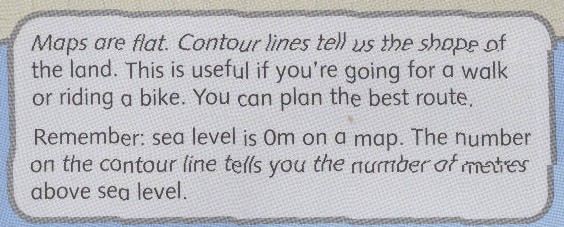
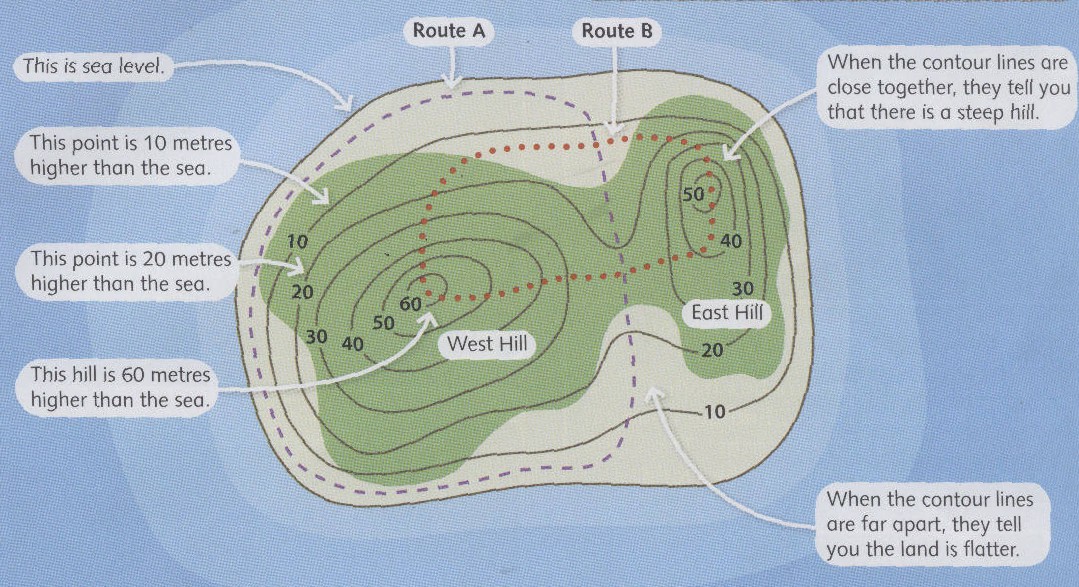
Inicio Ficheros adjuntos (Ventana nueva) Cuestionario SCORM Pregunta USING CONTOUR LINES ON MAPS Read the sentences and choose True or False. 1) Contour lines show the shape of the land. Respuestas Opción 1 It's true. Opción 2 It's false. Pregunta 2) See level is 10 metres high. Respuestas Opción 1 It's true. Opción 2 It's false. Pregunta 3) The numbers of the contour lines show the metres below sea level. Respuestas Opción 1 It's true. Opción 2 It's false. Pregunta 4) There is a steep hill when the contour lines are close together. Respuestas Opción 1 It's true. Opción 2 It's false. Pregunta 5) The land is flatter when the contour lines are far apart. Respuestas Opción 1 It's true. Opción 2 It's false. Pregunta 6) There are three hills in the island. Respuestas Opción 1 It's true. Opción 2 It's false. Pregunta 7) The East Hill is 60 metres high. Respuestas Opción 1 It's true. Opción 2 It's false. Pregunta 8) The West Hill is higher than the East Hill. Respuestas Opción 1 It's true. Opción 2 It's false. Pregunta 9) The route B is the most difficult. Respuestas Opción 1 It's true. Opción 2 It's false. Pregunta 10) The route A is the longest. Respuestas Opción 1 It's true. Opción 2 It's false. Habilitar JavaScript
Cuestionario SCORM Pregunta USING CONTOUR LINES ON MAPS Read the sentences and choose True or False. 1) Contour lines show the shape of the land. Respuestas Opción 1 It's true. Opción 2 It's false. Pregunta 2) See level is 10 metres high. Respuestas Opción 1 It's true. Opción 2 It's false. Pregunta 3) The numbers of the contour lines show the metres below sea level. Respuestas Opción 1 It's true. Opción 2 It's false. Pregunta 4) There is a steep hill when the contour lines are close together. Respuestas Opción 1 It's true. Opción 2 It's false. Pregunta 5) The land is flatter when the contour lines are far apart. Respuestas Opción 1 It's true. Opción 2 It's false. Pregunta 6) There are three hills in the island. Respuestas Opción 1 It's true. Opción 2 It's false. Pregunta 7) The East Hill is 60 metres high. Respuestas Opción 1 It's true. Opción 2 It's false. Pregunta 8) The West Hill is higher than the East Hill. Respuestas Opción 1 It's true. Opción 2 It's false. Pregunta 9) The route B is the most difficult. Respuestas Opción 1 It's true. Opción 2 It's false. Pregunta 10) The route A is the longest. Respuestas Opción 1 It's true. Opción 2 It's false. Habilitar JavaScript